We Analyzed Meta's 393-Acre Data Center Site in Temple, TX — Here's What the Terrain Shows
Meta's $800M hyperscale campus in Temple, Texas is one of the largest data center investments in the US. We loaded the actual AOI into Androne and ran a full terrain, flood zone, and infrastructure analysis. The results tell a compelling story about why this site was selected — and what any developer evaluating a similar parcel in central Texas should look for.
The Site: Industrial Blvd & Loop 363, Temple, TX
Meta's Temple campus occupies a roughly 393-acre parcel in the northwest corner of Temple, Bell County, Texas — bounded by NW H.K. Dodgen Loop (Loop 363) to the north and Industrial Boulevard to the east. The site sits at approximately 31.13°N, 97.41°W, about 3 miles west of I-35 and 45 minutes north of Austin.
The parcel was acquired under the Meta subsidiary Polmer LLC and falls within Bell County Tax Abatement Reinvestment Zone #43 — a greenfield site that was previously undeveloped agricultural/industrial land on the edge of Temple's expanding industrial corridor.
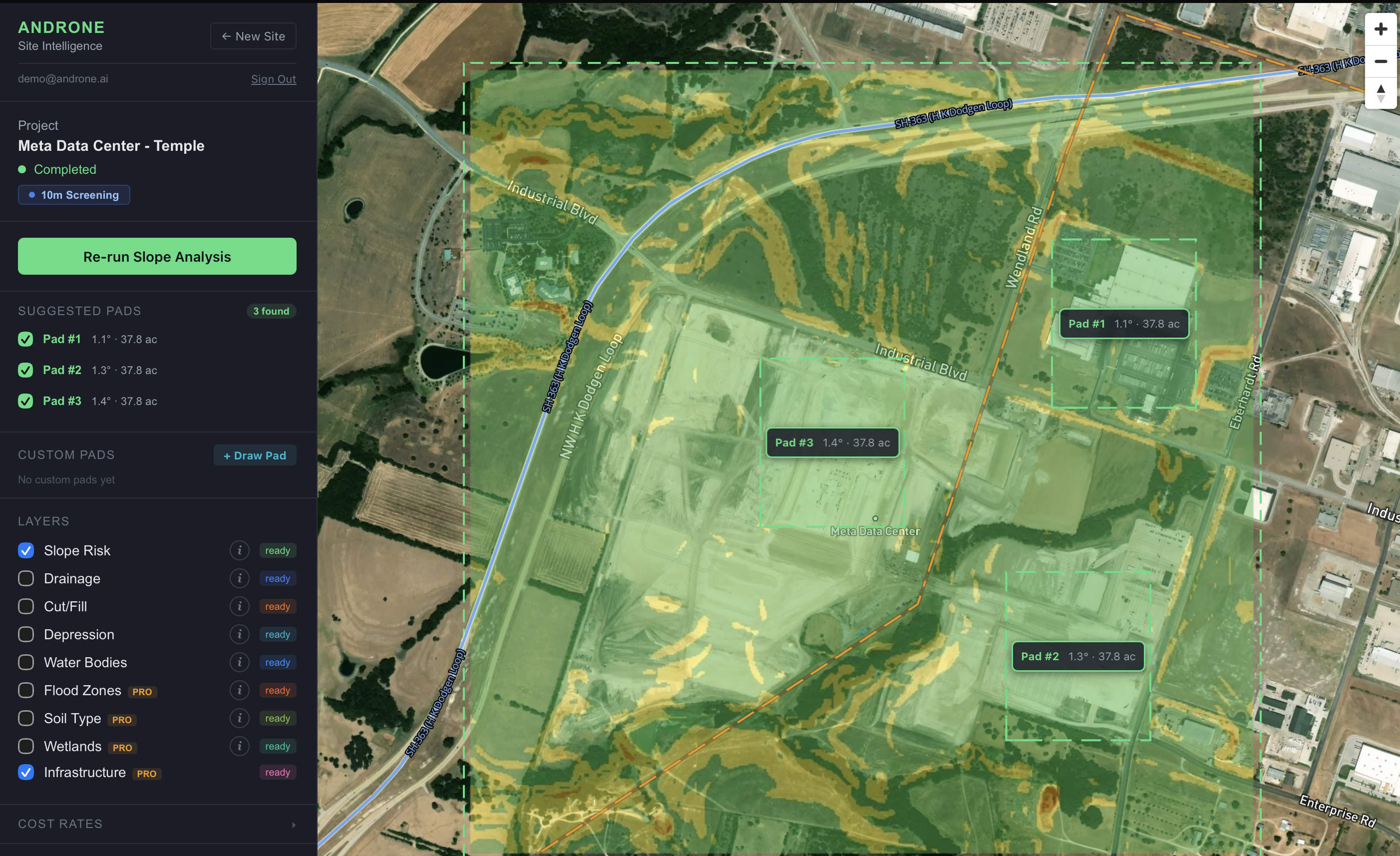
Terrain Analysis: Flat, With Purpose
The first thing Androne's terrain analysis reveals is why this site was shortlisted: it's remarkably flat. Central Texas transitions from the hilly Edwards Plateau to the Blackland Prairie in Bell County, and the northwest Temple industrial corridor sits squarely in that flat prairie transition zone.

Slope Distribution
Androne classifies terrain into four slope bands using USGS 1-meter LiDAR data:
82.8% of the site is flat terrain (<3°) — this is exceptional for a 393-acre parcel. Mean slope across the entire AOI is just 2.1°, with a maximum of 17.4° at an isolated edge. It means minimal cut/fill earthwork, reducing grading costs that can otherwise run $2–8/sqft on hillier Texas terrain.
Elevation Profile
The site sits between approximately 650–710 feet elevation (NAVD88), with a gentle southward drainage gradient. Total relief across the AOI is roughly 60 feet — concentrated mainly at the western edge near a drainage channel that runs toward the Leon River watershed.
Cut/Fill Estimates
For the best candidate pad locations identified by Androne, estimated earthwork volumes come in low:
- › Best pad (Pad #1): ~51,553 yd³ cut / ~51,551 yd³ fill — est. $619K–$1.5M earthwork
- › Pad #3 (Meta's actual location): ~113,888 yd³ cut / ~113,887 yd³ fill — est. $1.4M–$3.4M
- › Near-perfect 1:1 cut/fill balance across all three candidates — minimal haul-off required
- › Compared to Hill Country sites: 10–30x less earthwork volume per acre
Flood Zone Assessment: Mostly Favorable, With One Caveat
The FEMA flood zone overlay is where Temple's specific site selection story gets interesting. The bulk of the campus falls within FEMA Zone X — the minimal flood hazard designation — which is what you want for critical infrastructure.
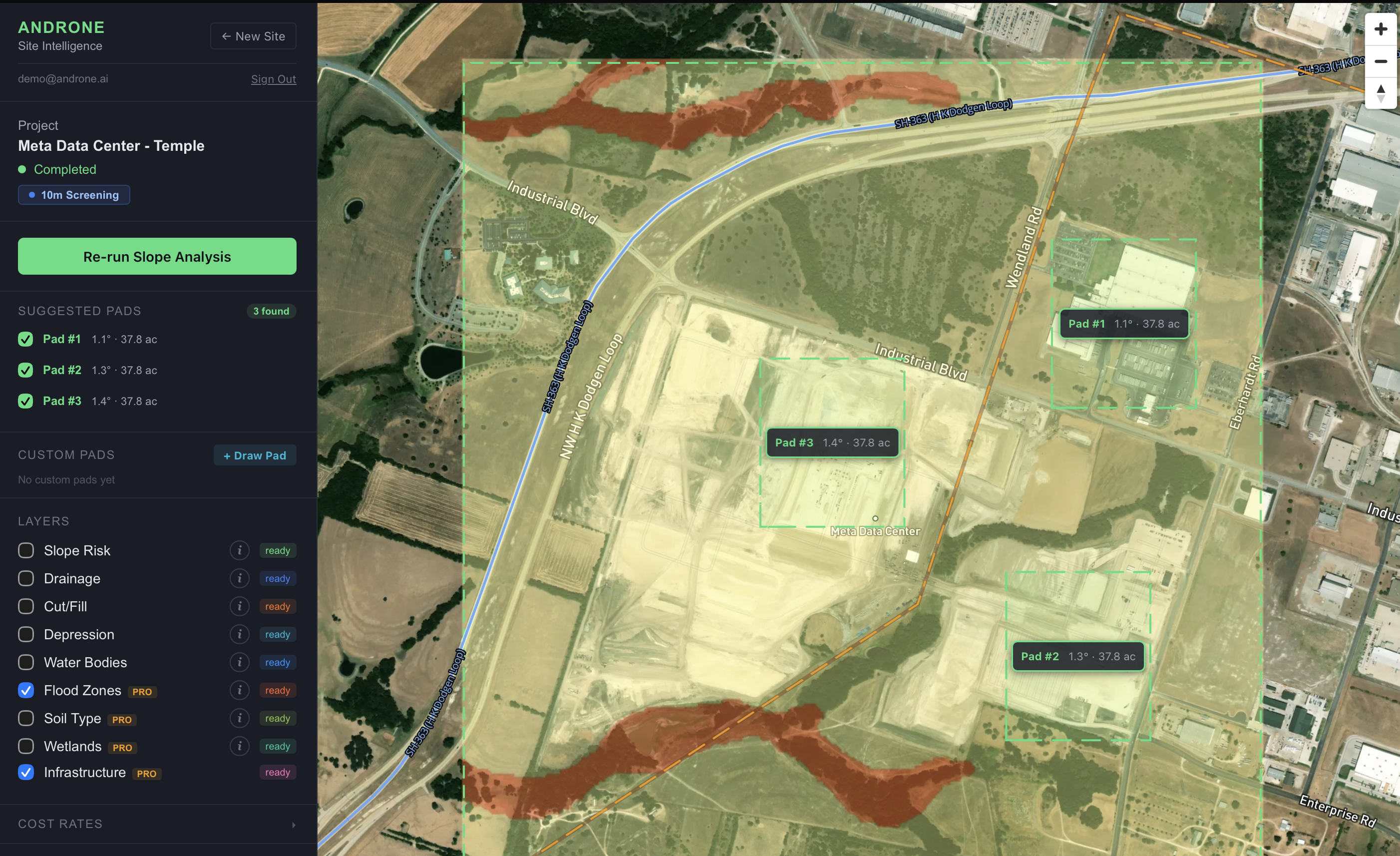
However, Androne's analysis flags a Zone AE corridor(100-year floodplain) running along the western boundary of the site. This drainage channel — a tributary feeding toward the Leon River — likely contributed to the 393-acre boundary being drawn to exclude that western edge from building footprints.
Infrastructure Proximity: Why Temple's Grid Won
Power infrastructure is the deciding variable for data center site selection. Androne's infrastructure layer pulls from HIFLD (Homeland Infrastructure Foundation-Level Data) and cross-references transmission corridors, substations, and highway access.
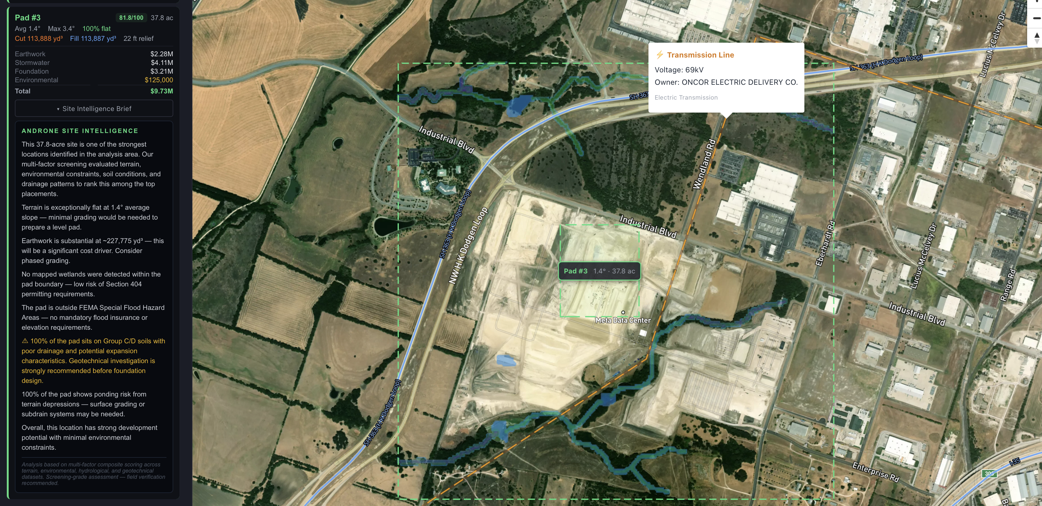
Substation Proximity
Androne identified multiple Oncor substations within 10 miles of the AOI. Most relevant:
The nearest Oncor substation is 2.2 miles east at 138 kV — a favorable distance for an interconnection study. ERCOT's February 2024 RPG filing (Oncor Temple Area Project) describes a direct grid upgrade — installing 600 MVA autotransformers — explicitly tied to the load growth from this corridor. That's the grid coming to meet the data center, not the data center hunting for capacity.
Transmission Corridors
Androne identifies 24 transmission lines within 5 miles of the campus — exceptional grid density. The nearest corridor is just 0.2 miles SE at 69 kV (Oncor Electric Delivery Co.), with 36 transmission lines within 10 miles total. This density is what makes 152 MW of continuous load readily supportable.
Highway Access
SH-363 (H.K. Dodgen Loop) is 0.5 miles west — a four-lane arterial that connects to I-35 (3 miles east). Heavy equipment, prefabricated MTRs, and generator deliveries have direct interstate-quality access without traversing residential streets — a non-trivial operational consideration when you're moving 750 prefabricated Multi-Trade Racks. Androne counts 132 highway segments within 5 miles of the AOI.
Pad Placement: Where Androne Said to Build
Androne's pad placement algorithm scores candidate locations based on weighted factors: slope (40%), FEMA flood zone (30%), wetland avoidance (15%), and proximity to site boundary buffer (15%). Running this on the Meta Temple AOI:
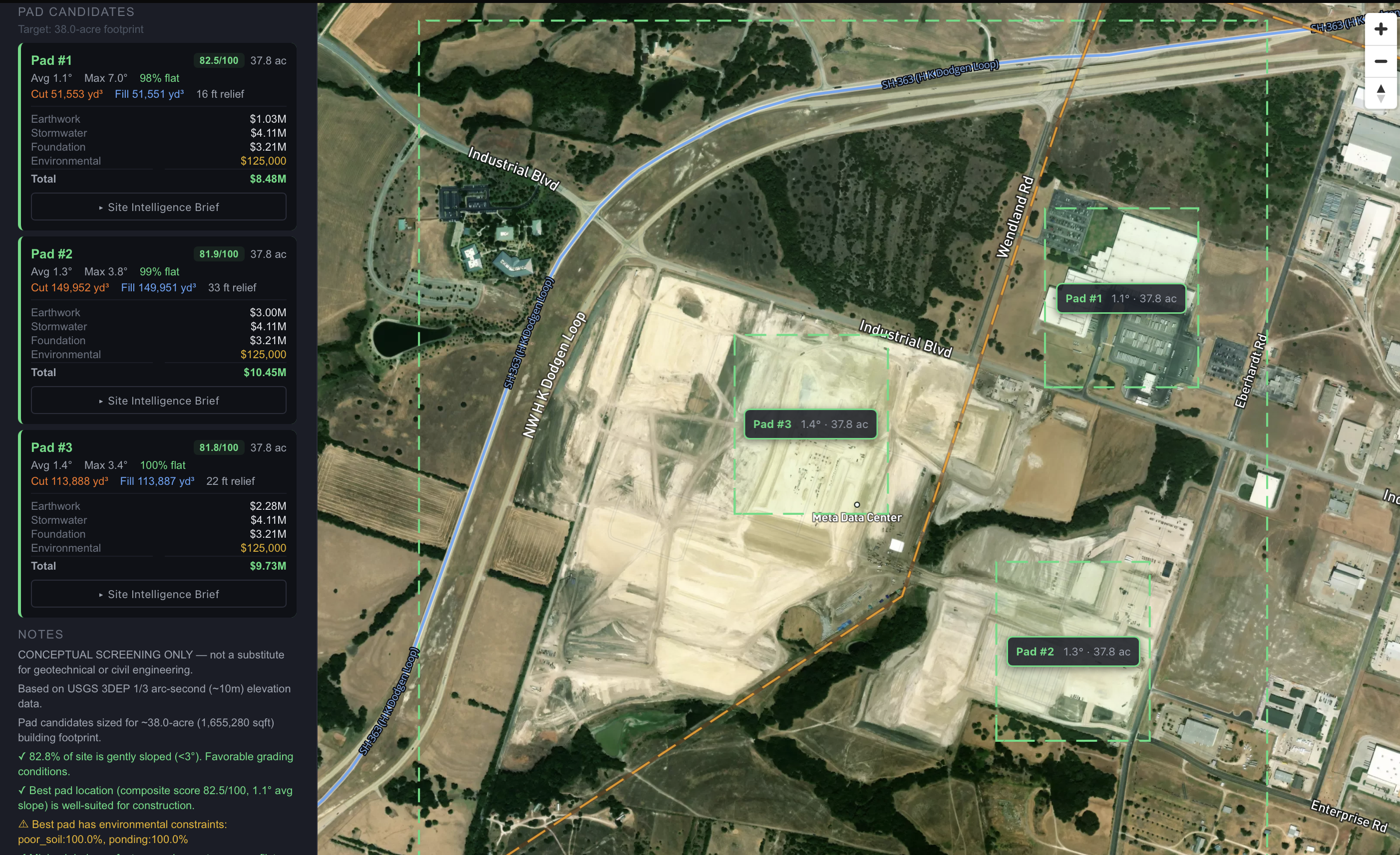
The top 3 pad candidates all cluster in the eastern half of the site — the Zone X, low-slope core. All three scored 82/100 with 0% wetland and 0% flood zone exposure. The algorithm correctly avoids the western SFHA corridor entirely.
The One Red Flag: 100% Group D Clay Soil
Not everything in this analysis is green. Androne's USDA SSURGO soil overlay flags 100% of the site as Hydrologic Soil Group D — the worst drainage classification. Expansive Blackland Prairie clay is notorious in central Texas for:
- ▲ Significant seasonal swelling and shrinkage — major foundation movement risk
- ▲ Very slow infiltration — surface ponding after rain (confirmed by Androne depression analysis)
- ▲ High plasticity — poor bearing capacity in its natural state
- ▲ Requires lime stabilization or deep foundation systems
This isn't a dealbreaker — it's a cost item. Data center foundations are already engineered for massive point loads. Meta's engineering teams will have scoped geotechnical investigation, lime stabilization, and likely pier-and-grade-beam foundations. But for a developer evaluating a competing site, this is exactly the kind of factor that adds $2–8M in foundation engineering costs that don't show up in land price comparisons.
What This Analysis Means for Texas Land Evaluators
The Meta Temple site is a case study in what a "tier 1" data center parcel looks like in central Texas. The combination of factors isn't accidental:
- Flat terrain (>70% <2% slope)Minimizes earthwork cost, which on 393 acres can save $10–40M vs hillier alternatives
- Zone X flood designation on buildable coreCritical for insurance, permitting, and lender approval on $800M infrastructure
- 345 kV substation within 2 milesEliminates transmission build cost; most greenfield sites require new substation construction ($15–50M)
- Interstate highway frontageConstruction logistics cost and operational supply chain efficiency over a 15-year asset life
- Minimal wetland conflictsPermitting risk and timeline risk on greenfield construction
The challenge for competing developers — or for site selectors evaluating the adjacent Rowan Digital 700-acre campus nearby — is that sites with all five factors simultaneously are vanishingly rare without systematic screening. You can't find the next Meta Temple by driving around. You need data.
The Temple Cluster Effect — and What's Next
The Meta announcement created a cluster effect. Rowan Digital Infrastructure broke ground in 2024 on a 300 MW, 700-acre campus nearby. Oppidan is building at 2325 Eberhardt Road directly across from Meta. Temple EDC is marketing the corridor aggressively.
The grid upgrades ERCOT is completing for Meta's load also create capacity for neighboring tenants. This is how industrial clusters form: one anchor tenant catalyzes grid investment that de-risks and cheapens power access for subsequent development.
For land evaluators, parcels within 5–10 miles of the Meta campus now have meaningfully better infrastructure access than they did in 2021. Running Androne on candidate sites in Bell and Coryell County can identify which of those parcels also have the terrain profile to compete.
Analyze a Site Near the Temple Corridor
Draw a boundary around any Bell County parcel and get the same terrain, flood, and infrastructure analysis we ran on the Meta site — in under 5 minutes.
Analyze a Site Free →